 Plan Your Trip Now
In This Guide
A Note Before You Read On
Before getting into trekking logistics, it's worth being clear about the scale of what happened. This was not a minor road closure — it is one of the deadliest disasters in Nepal in years. As of the most recent situation report, over 780 people have been confirmed dead in Nepal, more than 2,500 remain unaccounted for, and over 9,000 people have been rescued. Additional deaths and hundreds more missing have been reported across the border in Tibet. More than 90,000 people are estimated to have been affected across Rasuwa, Nuwakot, Dhading, Gorkha, Tanahun, Nawalparasi, and Chitwan districts. Rescue and recovery operations are still active. If you are planning travel in the region, that human context should shape your decisions — including patience with delays, sensitivity around affected communities, and support for relief efforts where possible.
With that said, here is what trekkers specifically need to know.
What Happened
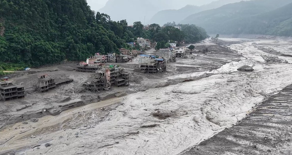
A catastrophic flash flood struck Nepal's Rasuwa district on the morning of August 26, 2026, at around 9:15 a.m. local time. It came down the Bhote Koshi River from the Tibetan side of the border without local warning — there had been no significant rainfall in the region in the prior 24 hours, which ruled out an ordinary monsoon flood.
Investigators believe the likely trigger was a large ice-rock avalanche near Langtang Lirung that blocked a tributary (the Lhende Khola) roughly 20 km upstream inside Tibet, forming a temporary debris-dammed lake. The subsequent collapse of that lake — a glacial lake outburst flood (GLOF) is considered the leading mechanism — sent a wall of water, mud, and debris downstream with enough force to register as a magnitude 5.2 tremor on seismometers. Some estimates put the surge height at roughly 100 meters above normal river level near the point of impact.
The flood devastated the Gyirong Port complex on the China–Nepal border (a major trade and tourism gateway), then tore through Timure and Syabrubesi in Rasuwa before continuing downstream through the Trishuli River system, causing damage as far away as Betrawati, Trishuli Bazaar, Devighat (Nuwakot), and beyond into Dhading, Gorkha, Tanahun, Nawalparasi, and Chitwan. Roughly 25 miles of road and multiple bridges were swept away, along with homes, hydropower facilities, and border infrastructure. Some victims' remains were reportedly carried as far as 240 km downstream into India.
Areas Directly Affected
- Timure – border town near the Rasuwagadhi customs crossing; the customs office and surrounding structures were badly damaged.
- Syabrubesi – the main gateway town for the Langtang Valley Trek; suffered significant structural damage.
- Betrawati, Trishuli Bazaar, Devighat (Nuwakot) – downstream settlements hit as the flood moved into the Trishuli system.
- Rasuwagadhi Rural Municipality – homes reported swept away, though many residents reached higher ground in time.
- Gyirong County, Tibet (China) – the Gyirong Port complex was destroyed; casualties and missing persons reported on the Chinese side as well.
- Further downstream flood warnings extended into Dhading, Gorkha, Tanahun, Nawalparasi, and Chitwan districts.
Fourteen hydropower projects and associated transmission infrastructure were damaged, cutting electricity to some communities, and the Furke Khola bridge connecting the Prithvi Highway to Dhading headquarters was also swept away.
Is the Langtang Valley Trek Affected?
Yes — but the impact is concentrated at the road access point, not (as far as currently known) on the high trekking trail itself.
Here's the breakdown:
What's damaged:
- Syabrubesi, the standard starting point for the Langtang Valley Trek, has suffered significant structural damage.
- The road and bridges linking Syabrubesi to Timure and on toward the Rasuwagadhi border have been destroyed.
- The wider Nuwakot–Rasuwa–Syabrubesi road corridor has been badly affected, and authorities have advised against traveling on it.
- The Kathmandu–Dhunche road in Rasuwa reopened for light, four-wheeled vehicles as of the latest update, which is a positive sign for gradual access recovery, but conditions remain fluid.
What's not confirmed as damaged:
- The actual trekking trail that climbs east out of Syabrubesi into the Langtang Valley itself was reported untouched by initial assessments.
- However, there has not yet been enough information to confirm whether upper trail sections, bridges, and teahouses beyond Syabrubesi have been affected. A local, on-the-ground trail inspection is still needed before it can be called fully clear.
Practical takeaway: Starting a Langtang Valley Trek from Syabrubesi right now is not recommended. Even if the upper trail itself proves intact, getting to the trailhead safely is currently the obstacle, road infrastructure is under repair, and the area is also absorbing rescue and relief operations that should not be complicated by trekker traffic. Anyone with a Langtang trip booked for the coming weeks should expect delays and stay in close contact with their operator, since this is a genuinely developing situation rather than a one-time disruption.
Is It Safe to Trek in Nepal Right Now? Status of Other Major Routes
The reassuring news for trekkers with plans elsewhere in Nepal: this flood is a Rasuwa/Bhote Koshi–Trishuli corridor event. Nepal's other major trekking regions sit on entirely separate river systems and road corridors, and have not been significantly affected.
| Trekking Region | River / Access System | Status |
|---|---|---|
| Langtang Valley | Bhote Koshi / Trishuli (via Syabrubesi) | Gateway town and access road damaged; trail status above Syabrubesi unconfirmed |
| Everest / Khumbu (EBC) | Dudh Koshi, accessed via Lukla flights | Running normally — separate drainage system from the Bhote Koshi–Trishuli corridor |
| Annapurna (ABC, Circuit, Poon Hill, Mardi) | Modi Khola / Marsyangdi, accessed via Pokhara | Running normally |
| Manaslu Circuit | Budi Gandaki | Running normally — different river system entirely |
| Upper Mustang | Kali Gandaki | Running normally |
| Tsum Valley | Budi Gandaki (same access as Manaslu) | Running normally |
| Nar Phu Valley | Marsyangdi (same access as Annapurna Circuit) | Running normally |
A short closure was reported on the Prithvi Highway (the main Kathmandu–Pokhara road), but this was expected to clear quickly and is a minor factor for travelers heading to the Annapurna and Manaslu regions rather than a major obstacle.
Alternative Trekking Destinations If You Had Langtang Planned
If your Langtang trip is on hold, Nepal has several excellent alternatives running normally. Here's a practical rundown of each.
Everest Base Camp (EBC) Trek
The classic high-altitude trek through the Khumbu region to the foot of the world's highest mountain, passing through Namche Bazaar, Tengboche, and Dingboche. Typically 12–14 days round trip, starting with a flight to Lukla. Since it sits in the Khumbu on the Dudh Koshi drainage, it is geographically isolated from the Rasuwa flood zone. Do keep an eye on Lukla flight schedules and weather, which is standard practice for this route regardless of the flood.
Annapurna Base Camp (ABC) Trek
A shorter, scenic trek (7–10 days) through rhododendron forests and Gurung villages to the base of Annapurna I, accessed from Pokhara via the Modi Khola valley. Unaffected by the flood and a strong choice if you want dramatic mountain views without the altitude or logistics of EBC.
Annapurna Circuit Trek
A longer classic (12–18 days depending on route and transport used) circling the Annapurna massif via the Marsyangdi valley, crossing the Thorong La pass (5,416 m) into the Kali Gandaki valley and Upper Mustang's edge. Access from Besisahar or Pokhara is unaffected.
Manaslu Circuit Trek
A restricted, less-crowded circuit (14–18 days) around the eighth-highest mountain in the world, following the Budi Gandaki River — a completely separate drainage from the Bhote Koshi/Trishuli system. Requires a special permit and guide. Running normally and worth considering if you wanted Langtang's remoteness without the crowds.
Upper Mustang Trek
A high desert trek (10–14 days) into the former Kingdom of Lo, north of the Annapurna range along the Kali Gandaki valley — dramatically different scenery from Langtang, with cave monasteries, red cliffs, and Tibetan Buddhist culture. Requires a restricted-area permit. Unaffected by the flood.
Tsum Valley Trek
A remote, culturally rich valley adjoining the Manaslu region (usually combined with the Manaslu Circuit for a 15–20 day trip), known for its Tibetan Buddhist monasteries and relatively untouched villages. Same Budi Gandaki access as Manaslu — unaffected.
Nar Phu Valley Trek
A hidden valley trek (10–14 days) usually combined with the Annapurna Circuit, following the Marsyangdi and then a side valley into two remote, restricted villages. Unaffected — same access corridor as the Annapurna Circuit.
Ghorepani Poon Hill Trek
A shorter, beginner-friendly trek (4–5 days) through the Annapurna foothills to the famous Poon Hill sunrise viewpoint over the Annapurna and Dhaulagiri ranges. Ideal if you had a short window originally allotted for Langtang. Unaffected.
Mardi Himal Trek
A quieter, increasingly popular short trek (5–6 days) up a ridge with close-up views of the Machhapuchhre (Fishtail) massif, accessed from Pokhara via the Annapurna foothills. Unaffected and a good lower-traffic alternative.
Practical Advice for Trekkers Right Now
1. Don't attempt Langtang from Syabrubesi at present. Even setting aside trail conditions, the road corridor is damaged, under repair, and being used for rescue and relief work.
2. Talk to your trekking operator before rebooking. Reputable Nepal-based agencies are actively rerouting or postponing Langtang bookings and can advise on realistic timelines — this is a fast-changing situation, and secondhand social media reports are not reliable for trail-condition decisions.
3. Everest, Annapurna, and Manaslu routes are open and represent solid alternatives if your dates are fixed.
4. Check flight and highway status close to departure. The Prithvi Highway and some regional roads have had temporary closures; these are usually short but worth confirming.
5. Expect broader disruption in Kathmandu and Pokhara logistics — hotel availability, guide/porter allocation, and vehicle transport may be affected as resources shift toward relief work, even outside the flood zone itself.
6. Consider donating to verified relief efforts (such as the Nepal Red Cross Society or Nepal's official relief fund) if you're not traveling, given the scale of the humanitarian need.
7. Register with your embassy if you're already in Nepal or Tibet near the affected corridor — several embassies are coordinating with local authorities to assist travelers.
Bottom Line
The Langtang Valley Trek is affected — its gateway town of Syabrubesi and the access road into Rasuwa have suffered serious damage, and starting the trek from there is currently not advisable, even though the upper trail itself may turn out to be intact once inspected. Every other major Nepal trekking region — Everest, Annapurna (including ABC, the Circuit, Poon Hill, and Mardi Himal), Manaslu, Tsum Valley, Nar Phu Valley, and Upper Mustang — sits on separate river and road systems and is running normally. If your Langtang trip is disrupted, any of the alternatives above offer a comparable (in some cases even more dramatic) Himalayan trekking experience while the Rasuwa region focuses on recovery.
Ready to trek in the Himalayas?
Get itinerary guidance and local support from the Team Ram Adventure specialists.