 Plan Your Trip Now
In This Guide
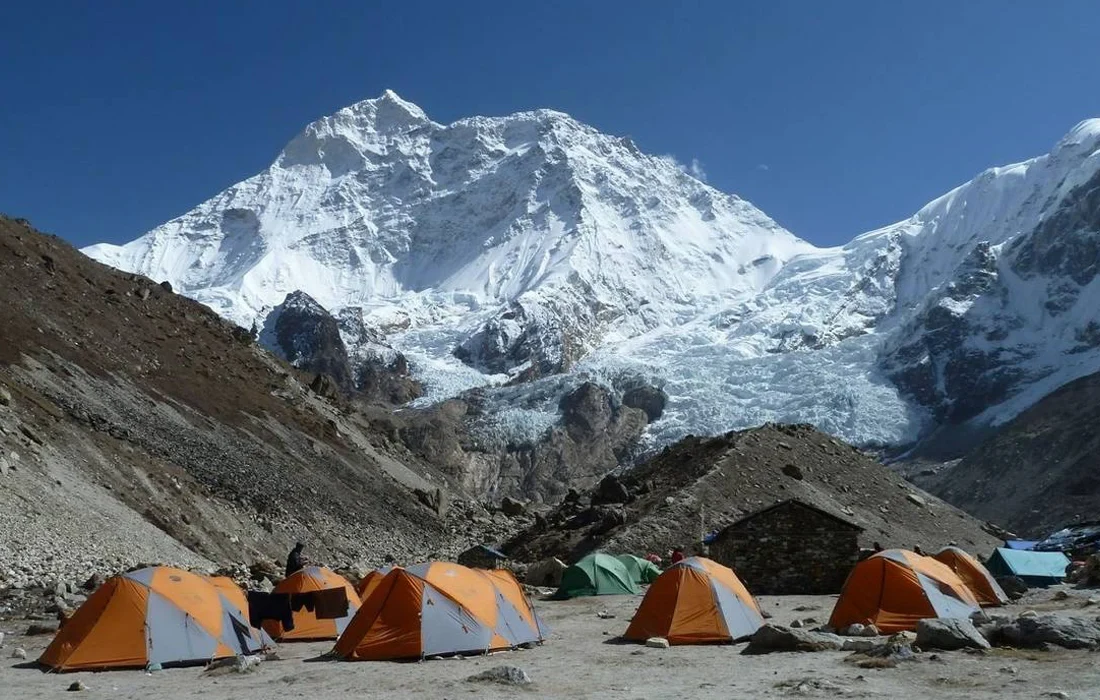
Standing in front of Mt. Makalu (8,463m), the fifth highest mountain on Earth, is one of the great experiences in the Himalayas. It is also one of the most remote and least crowded. But the reward comes with a real challenge: altitude.
The trail runs from the warm lowlands of the Arun Valley near Num (1,560m) to Makalu Base Camp at 4,870m. Along the way it crosses three high passes, including Shipton La (4,170m). Several of the days gain a lot of height, and the pacing matters.
This guide breaks down the full Makalu Base Camp Trek altitude profile. It covers the daily elevation gain, the sleeping altitudes, the acclimatization strategy and the practical steps that help you reach base camp safely. It is based on the 13-day Makalu Base Camp Trek operated by Team Ram Adventure.
Makalu Base Camp Trek at a Glance
| Trip Fact | Details |
|---|---|
| Highest sleeping point | Makalu Base Camp, 4,870m |
| Side trip | Up to about 5,500m towards Advance Base Camp |
| Trek duration | 13 days (20 days including Kathmandu, flights and buffer days) |
| Grade | Moderate (suited to experienced trekkers who can walk 6-7 hours a day) |
| Accommodation | Teahouse and camping |
| Group size | 2-12 people |
| Best seasons | February to May and September to December |
| Price | From US$2,999 per person (check the trip page for the current offer) |
Why the Altitude Profile Matters on This Trek
The Makalu trail has a distinctive shape. Unlike treks that climb steadily, this one starts low and climbs sharply in the first week. It then goes over three passes before descending into the Barun Valley, where it climbs again toward base camp.
Three features make the profile unusual:
- A big early climb. You gain roughly 1,400m between Tashigaon and Khongma in a single day.
- Three passes in one stretch. Gongar La, Shipton La (4,170m) and Keke La (4,125m) are crossed close together.
- A dip before the final push. The route drops into the Barun Valley, which lets your body recover before the highest nights.
Knowing this shape in advance lets you pace yourself properly. It is also why the trek includes a flexible acclimatization day at Khongma.
Makalu Base Camp Trek Altitude Profile: Day-by-Day Elevation Gain
The table below follows the itinerary on the Makalu Base Camp Trek page. Figures are rounded, and the “sleeping change” column shows the difference between the previous night’s altitude and the current one. That difference is the most useful number for acclimatization.
| Day | Route | Sleeping Altitude | Sleeping Change | Walking Time |
|---|---|---|---|---|
| 1-2 | Kathmandu arrival and preparation | 1,400m (approx.) | n/a | n/a |
| 3-4 | Fly to Tumlingtar, drive to Num | 1,560m | Start of trek | 4-5 hrs drive |
| 5 | Num to Seduwa | 1,500m | -60m | 4-5 hrs |
| 6 | Seduwa to Tashigaon | 2,100m | +600m | 4-5 hrs |
| 7 | Tashigaon to Khongma | 3,500m | +1,400m | 4-5 hrs |
| 8-9 | Acclimatization at Khongma, or continue to Dobato over 3 passes | 3,862m (Dobato) | +362m | 4-5 hrs |
| 10 | Dobato to Yangle Kharka | 3,540m | -322m | 5-6 hrs |
| 11 | Yangle Kharka to Langmale | 4,410m | +870m | 4-5 hrs |
| 12 | Langmale to Makalu Base Camp | 4,870m | +460m | about 3 hrs |
| 12+ | Optional side trip towards Advance Base Camp | up to 5,500m (day trip) | Climb high, sleep low | variable |
| 13-18 | Return trek to Tumlingtar | Descending | Descending | variable |
| 19 | Fly Tumlingtar to Kathmandu | 1,400m | n/a | n/a |
| 20 | Departure | n/a | n/a | n/a |
Kathmandu is about 1,400m. Heights and times may vary slightly with trail conditions and season.
Stage-by-Stage Breakdown
Stage 1: The Low Country (Tumlingtar to Num, 410m to 1,560m)
After a scenic flight from Kathmandu, you land at Tumlingtar (410m). A local jeep takes you through Khandbari, Manebhanjyang (1,100m), Bhotebas (1,740m), Gogane (1,720m) and Chichira (1,980m) before arriving in Num.
Altitude is not a concern here. The main factor is road conditions. In the monsoon and early post-monsoon months the road can be bumpy and muddy, so the drive may stop short of Num and add a day. That is why the itinerary allows two days to reach Num.
Stage 2: Down to the Arun, Then Up (Num to Seduwa, 1,500m)
Day 5 is a descent followed by a climb. You drop about 800m to the Arun River (760m), cross a suspension bridge, and climb roughly 800m to Seduwa (1,500m). Your sleeping altitude barely changes, but the day is a real workout for the legs. It is a good chance to find your pace.
Seduwa is also where you register your permits at the Makalu Barun National Park office.
Stage 3: Through the Rai and Sherpa Villages (Seduwa to Tashigaon, 2,100m)
A gentle climb of about 600m through terraced fields and forest brings you to Tashigaon (2,100m), the last village on the trek. At this height there is no real altitude effect yet.
Stage 4: The Big Climb (Tashigaon to Khongma, 3,500m)
This is the biggest sleeping gain of the trek: about 1,400m. The trail climbs through dense forest via Danda Kharka (2,650m), Wishisa (3,110m) and Kongma Danda (3,500m) before reaching Khongma.
Most trekkers feel altitude for the first time here. Sleeping at 3,500m is above the height where acute mountain sickness (AMS) becomes a possibility. This is also why Team Ram Adventure builds in a flexible rest day.
Stage 5: Acclimatization Day, then the Three Passes (Khongma to Dobato, 3,862m)
The itinerary offers a choice on Days 8-9:
- If you feel uncomfortable, spend an extra night at Khongma and take a day hike to higher ground. Explore the surrounding forest and enjoy the mountain views.
- If you feel well, continue towards Dobato over three passes: Gongar La (3,600m), Shipton La (4,170m) and Keke La (4,125m).
On a clear day you can see Makalu, Chamlang, Baruntse, Kanchenjunga and Jannu from the passes. You also pass Kalopokhari (the black lake) and Thulo Pokhari (the big lake) before the descent to Dobato.
Your sleeping altitude rises only about 362m, but the day takes you above 4,100m. That makes it a useful “climb high, sleep low” exposure.
Stage 6: The Recovery Dip (Dobato to Yangle Kharka, 3,540m)
You descend into the Barun Valley and sleep about 320m lower than the night before. This dip helps your body consolidate its acclimatization before the final climb.
The trail follows the Barun River and includes a landslide-prone section that takes roughly an hour, where care is needed. The walk is longer (5-6 hours), but altitude stress is low.
Stage 7: Climbing into the High Himalaya (Yangle Kharka to Langmale, 4,410m)
This is the second-largest sleeping gain, about 870m. You pass Ripuk, Tadhosa (with views of Shiva’s waterfall) and Jack Kharka before reaching Langmale. Views of Pyramid Peak, Peak 4, Peak 5, Peak 6 and Chamlang open up.
A gain of 870m in one day is above the commonly cited guideline of about 300-500m of sleeping gain per day above 3,000m. Walk slowly, drink plenty of fluids, and tell your guide about any headache, nausea or poor sleep. If you feel unwell, a rest day here is better than pushing on.
Stage 8: Makalu Base Camp (4,870m)
The walk from Langmale to base camp is short, about 3 hours, passing Shersong (4,630m). The rise in sleeping altitude is about 460m. With time left in the afternoon, you can explore the open valley or begin the side trip towards Advance Base Camp, reaching about 5,500m.
The itinerary suggests spending a night at base camp if you plan the side trip. Because you climb higher by day and return to sleep lower, that follows the “climb high, sleep low” principle.
Stage 9: The Return (Days 13-18)
You retrace your route to Tumlingtar. Descending quickly brings relief from altitude symptoms, though the long downhill stretches are hard on knees and calves. Trekking poles help, and they are optional on the gear list.
Acclimatization Strategy: How the Itinerary Protects You
A well-designed Makalu itinerary uses several proven principles:
- Gradual exposure. The first four days stay under 2,200m, so you start the high section fit and rested.
- A flexible rest day at Khongma (3,500m). It sits where altitude effects typically begin.
- Passes followed by descents. Crossing 4,100m+ passes and then sleeping lower is a recognized way to build tolerance.
- The Yangle Kharka dip. Sleeping at 3,540m after Dobato gives your body a chance to catch up.
- Short final approach. Reaching base camp takes only about 3 hours from Langmale, so you arrive with energy.
- Local guides. Experienced guides watch for early symptoms and can adjust the plan.
Altitude Sickness on the Makalu Trek: Know the Signs
At 3,500m and above, some trekkers develop AMS regardless of fitness. Common early signs include:
- Headache that persists or worsens
- Nausea or loss of appetite
- Dizziness or unusual fatigue
- Poor sleep
- Shortness of breath out of proportion to effort
The golden rules:
- Never ascend with worsening symptoms. Rest, hydrate and reassess.
- If symptoms get worse, descend. Descent is the most reliable treatment.
- Be honest with your guide. Early reporting leads to better decisions.
- Severe symptoms (confusion, loss of balance, breathlessness at rest, a wet cough) are medical emergencies requiring immediate descent.
This is general information, not medical advice. Talk to your doctor before the trek, especially about medication such as acetazolamide (Diamox).
Practical Tips for Handling the Altitude
- Walk slowly. On the climb to Khongma and Langmale, a steady pace beats speed.
- Hydrate well. Aim for 3-4 litres a day at altitude.
- Eat regularly, even when appetite drops. Carbohydrates fuel your body.
- Avoid alcohol and smoking, especially above 3,500m.
- Dress in layers. The temperature swing between Num and Makalu Base Camp is large. The trek’s equipment list includes a sleeping bag rated to zero degrees and a down jacket.
- Train before you come. Cardio, hill walking and leg strength all help. The trek is best suited to people who can walk 6-7 hours a day.
- Buy proper travel insurance. Make sure it covers high-altitude trekking and emergency evacuation. Trek insurance is not included in the package.
- Allow buffer days. Weather, road conditions and flights can change. The 20-day plan builds in flexibility.
Best Time to Trek Makalu for Comfortable Altitude Conditions
The best seasons are February to May and September to December.
- Spring (March-May) brings blooming rhododendron around Dobato and generally stable weather.
- Autumn (late September-December) offers crisp, clear mountain views. Early October roads can still be muddy after the monsoon.
- Winter (December-February) is colder at altitude, so higher passes may hold snow.
Cold nights at Langmale and base camp can make altitude feel worse, so proper warm gear matters in every season.
What’s Included in the Trek
According to the trip page, the package includes:
- 3 nights’ hotel accommodation with breakfast in Kathmandu
- Experienced guide and required helpers
- Teahouse or camping arrangements
- Locally available meals during the trek
- Internal flights
- Trek logistics including permits and transport
Not included are lunch and dinner in Kathmandu, personal expenses, trek insurance and staff tipping.
Explore More Remote Himalayan Treks
If Makalu inspires you, these other eastern and high-altitude routes from Team Ram Adventure may interest you:
- Kanchenjunga Base Camp Trek: a 24-day journey to the third highest mountain
- Kanchenjunga Circuit Trek: north and south base camps in one trip
- Everest Base Camp Trek: Nepal’s classic high-altitude route
- Manaslu Circuit Trek: a remote circuit with a high pass
- Mera Peak Climbing: a step up for those wanting a summit
- All Eastern Region Treks and Trekking in Nepal
Top 15 FAQs About the Makalu Base Camp Trek
1. How high is Makalu Base Camp?
Makalu Base Camp is at about 4,870m (15,978 ft). The optional side trip towards Advance Base Camp reaches roughly 5,500m.
2. How high is Mt. Makalu?
Mt. Makalu stands at 8,463m and is the fifth highest mountain in the world.
3. How difficult is the Makalu Base Camp Trek?
The trek is graded moderate but remote. It suits experienced trekkers who can walk 6-7 hours a day. The route includes steep climbs, three passes and a landslide-prone stretch in the Barun Valley.
4. What is the biggest elevation gain in a single day?
The biggest sleeping gain is from Tashigaon (2,100m) to Khongma (3,500m), about 1,400m. The next largest is Yangle Kharka to Langmale, about 870m.
5. Is altitude sickness a risk on this trek?
Yes, as on any trek above 3,000m. The itinerary helps by including a flexible rest day at Khongma and a descent to Yangle Kharka, but individual reactions vary. Recognize symptoms early and descend if they worsen.
6. Where is the acclimatization day on the Makalu trek?
The flexible acclimatization day is at Khongma (3,500m) on Days 8-9. If you feel well, you can continue to Dobato instead.
7. How many passes do you cross?
You cross three passes in one stretch: Gongar La (3,600m), Shipton La (4,170m) and Keke La (4,125m).
8. How many days does the trek take?
The trek itself is 13 days. Including arrival, preparation, flights and departure, the full program is 20 days.
9. What is the best time to trek to Makalu Base Camp?
February to May and September to December. Spring brings rhododendron blooms and autumn offers clear skies.
10. How do I get to the start of the trek?
You fly from Kathmandu to Tumlingtar, then take a local jeep to Num (about 4-5 hours). The itinerary allows two days in case road conditions are poor.
11. Where do we stay during the trek?
You stay in teahouses or tented camps. Lodges are used where available, and camping elsewhere.
12. Do I need a guide and permits?
Permits are required, and the package arranged by Team Ram Adventure includes an experienced guide, helpers and trek permits. You register at the Makalu Barun National Park office in Seduwa.
13. What does the Makalu Base Camp Trek cost?
The listed price is from US$2,999 per person (previously US$3,199), with no booking fees. Prices and offers change, so confirm on the trek page.
14. What should I pack for the trek?
Layered clothing, waterproof shell, down jacket, a sleeping bag rated to zero degrees, sturdy boots, headlamp, sunglasses, gloves, a daypack and a basic first aid kit. The full list is on the trip page, and gear can also be hired or bought in Thamel, Kathmandu.
15. Is travel insurance necessary?
Yes. Make sure your policy covers high-altitude trekking, medical expenses and air ambulance evacuation. Insurance is not included in the package.
Ready to Trek to the Foot of the World’s Fifth Highest Peak?
The Makalu Base Camp Trek is one of Nepal’s quiet masterpieces. It offers wilderness, cultural villages, rhododendron forests, three passes and an unforgettable face-on view of Makalu. Its altitude profile is demanding but manageable. A steady pace, a good acclimatization plan and an experienced team make the difference.
Team Ram Adventure has organized treks across Nepal for years and is recommended on Tripadvisor. Talk to our experts, ask about group departures, or customize your own trip.
- View the full Makalu Base Camp Trek itinerary
- Make an inquiry
- Why book with us?
- Contact us or WhatsApp +977 9851125603
- Email: info@teamramadventure.com
Ready to trek in the Himalayas?
Get itinerary guidance and local support from the Team Ram Adventure specialists.