
 Plan Your Trip Now

In This Guide

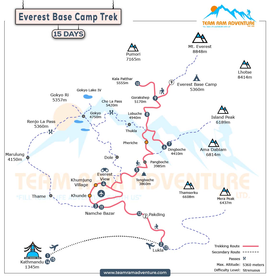
The Everest Base Camp Trek route map follows a classic Himalayan trail through the Khumbu region of Nepal. This trekking route connects mountain villages, glacial valleys, suspension bridges, monasteries, and high-altitude settlements before reaching the base of the world’s highest peak. Understanding the map helps trekkers track altitude gain, acclimatization stops, and key landmarks along the journey.
Kathmandu – Starting Point

The journey begins in Kathmandu, Nepal’s capital. Trekkers prepare permits and gear before flying to Lukla. Kathmandu also offers cultural exploration opportunities, including UNESCO World Heritage Sites such as Durbar Square and Swayambhunath Stupa.
Lukla – Gateway to Everest
After a scenic mountain flight, trekkers land in Lukla at 2,860 meters. Lukla marks the official starting point of the Everest Base Camp trekking route. From here, the trail descends toward Phakding along the Dudh Koshi River.
Phakding
Phakding sits beside the Dudh Koshi River and serves as the first overnight stop. The route map shows gentle elevation gain here, allowing trekkers to adjust gradually before major ascents.
Namche Bazaar – Acclimatization Hub

Namche Bazaar at 3,440 meters is the largest Sherpa town in the region. The trail climbs steeply to reach this horseshoe-shaped settlement. Most trekkers stay two nights here for acclimatization. The route map highlights Namche as a key altitude adjustment point.
Tengboche – Spiritual Landmark

From Namche, the trail continues along ridge lines toward Tengboche at 3,860 meters. Tengboche is home to the region’s most important monastery. The route offers panoramic views of Everest, Ama Dablam, and Lhotse.
Dingboche – Alpine Transition
Dingboche sits at 4,410 meters. The landscape becomes more rugged and vegetation sparse. The trekking map marks Dingboche as another acclimatization stop before entering higher elevations.
Lobuche – Glacial Terrain
The trail climbs past Thukla Pass memorials before reaching Lobuche at 4,910 meters. Glacial terrain dominates this section of the route. Trekkers feel thinner air and colder temperatures here.
Gorak Shep – Final Settlement
Gorak Shep at 5,140 meters serves as the final overnight stop before Everest Base Camp. The trail follows the Khumbu Glacier across rocky terrain.
Everest Base Camp – 5,364 Meters
The ultimate destination is Everest Base Camp at 5,364 meters. During climbing season, colorful expedition tents fill the glacier. The route map ends here for most trekkers before returning.
Kala Patthar – Best Viewpoint
After visiting base camp, trekkers climb Kala Patthar at 5,545 meters. This viewpoint offers the clearest and closest panoramic view of Mount Everest and surrounding Himalayan peaks.
Sagarmatha National Park
The entire trekking route from Monjo onward lies inside Sagarmatha National Park, a UNESCO World Heritage Site. The park protects rare wildlife and fragile alpine ecosystems.
Optional Route Extensions
The route map also connects to alternative trails such as the Gokyo Lakes trek via Cho La Pass and the Chhukung Valley route. These extensions add high passes and additional glacial landscapes to the classic Everest Base Camp Trek.
The Everest Base Camp Trek route map clearly outlines a gradual ascent from Kathmandu to Lukla, through Namche Bazaar, Tengboche, Dingboche, Lobuche, Gorak Shep, and finally Everest Base Camp, with Kala Patthar as the highest viewpoint. Careful planning and acclimatization make this Himalayan journey both achievable and rewarding.
Ready to trek in the Himalayas?
Get itinerary guidance and local support from the Team Ram Adventure specialists.


